Chamoli disaster, Uttarakhand, northern India, 7th February 2021
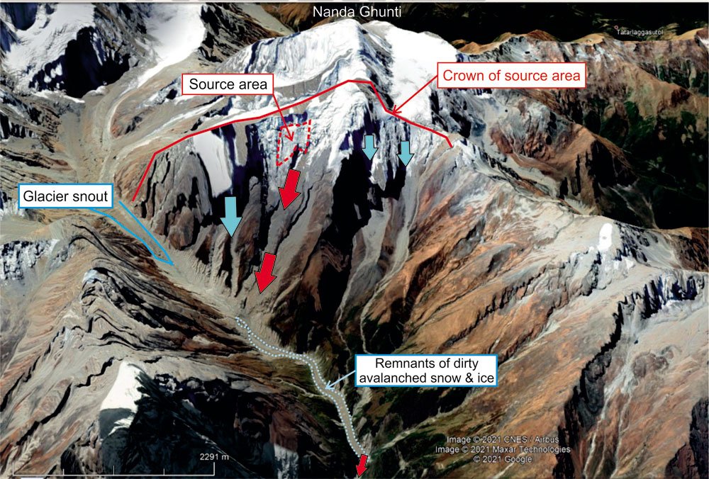
A devastating debris flow occurred on Sunday 7th February in Chamoli District, Uttarakhand, northern India, resulting in 26 deaths thus far with about 171 people missing including 35 construction workers trapped in a tunnel at the Rishi Ganga HPP at the time of writing. It appears to have originated as a major snow, ice, and rock avalanche and had nothing to do with a glacier or Glacial Lake Outburst Flood despite press reports stating that it was. The source area, which has been identified as being located around 3.25 km to the north of Nanda Ghunti peak (6,309 m), has a history of significant rock/ice avalanches and landslides.
From Planet Labs satellite imagery acquired the day before and day after the event it is clear where the source of the event was. It had an area of ~200,000 m² and was probably tens of metres thick. It would appear from initial inspection of this satellite image that the top of the source area is at 5,600 m. The snow, ice, and rock mass fell to 3,800 m down the steep mountain flank pulverising on impact. The major landslide/rock avalanche also produced a huge and widespread dust cloud along the valley seen on some videos of the event and captured on the Planet Labs satellite images. It is thought at this preliminary stage that the landslide/rock avalanche collapsed onto the floor of the valley about 1.5 km downstream from the adjacent glacier snout. From analysis of time series satellite imagery, it is thought that there were several previous large snow and ice avalanches in the period between 2014 and 2016. There was one notable significant snow and ice avalanche between the 19th and 24th September 2016 that ran-out along a ~3.4-km stretch of the river valley, leaving an area of about 300,000 m² of variably thick remnant compressed snow and ice. It is not known whether much of this remnant ice was there at the time of the latest landslide or if even more had accumulated from more recent snow and ice avalanches. The Rishi Ganga River has melted a tunnel underneath this residual avalanche material. Where the tunnel roof has collapsed, windows through reveal the river flowing below. This latest major rockslide has fallen onto this avalanche remnant ice area, probably melted it from the frictional heat associated with the pulverised landslide fragments, contributing of the order of 1 million m³ of water on top of the existing river flow. Coupled with the large volume of debris from the landslide itself (of the order of 10 million m³?), the combined mass was able to travel with considerable speed down valley, wreaking the scale of devastation that was captured so dramatically by video in several locations downstream. Figures and specific details quoted here are very approximate and undoubtedly will be revised once more imagery becomes available.
Prof. John M. Reynolds, MD at Reynolds International Ltd, has been called by media outlets for his opinion on what happened. One interview was prominently featured in New Civil Engineer online (https://www.newcivilengineer.com/latest/india-dam-collapse-entirely-foreseeable-and-should-not-be-happening-in-2020-10-02-2021/) on 10th February 2021. More news on this will be made available as RIL undertakes more forensic analysis of this event.