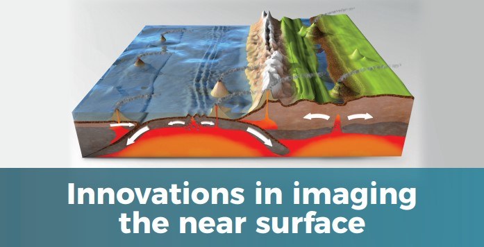
July 2021 Newsletter

Welcome to this month’s newsletter with the focus on the application of environmental and engineering geophysics to ground investigations. With the UK Government flagging its policy of ‘Build Back Better’ and the requirement to utilise brownfield sites more, there is growing demand for more costeffective and technically robust ground investigations. Now the Covid-19 pandemic lockdown restrictions are being relaxed, it is enabling more field work to be undertaken more easily with wider travel being permitted. Furthermore, with the Climate Emergency still facing society worldwide, we really do need to up our collective game in how we do things with our built environment.
It should be beholden on the engineering sector to optimise what we do and how we do it by accessing all the available relevant tools and to use them effectively and efficiently to achieve better and more energy-efficient outcomes. To this end, geophysical techniques can play a very significant part to complement more traditional intrusive methods, all of which should be integrated into 3D Ground Models and other forms of visualisation.
As technology continues to develop apace, so too do geophysical methods, in terms of instrumentation and in modes of deployment, two facets we explore this month. It has long been our ethos to provide the best technical advice to deliver costeffective value-for-money solutions to resolve clients’ problems and investigation needs and provide peace of mind through risk reduction. Read on to find more about these topics and benefit from our top tips on using geophysical techniques effectively.
Rubbish imaging and saving our planet!
The date when humanity’s demand forecological resources and services each year exceed what the Earth can regenerate in that year is known as Earth Overshoot Day (EOD). In the 1960s, humankind used less resources, but our annual rate of consumption has skyrocketed ever since such that we now devour the equivalent of one Earth’s resources in much less than a calendar year, each year. The earliest EOD on record was on 29th July 2019 and has been occurring earlier each year until the Covid-19 pandemic struck. If the global population lived like the UK, we would need the resources of 2.7 Earth equivalents each year.
Over the last five years there has been a growing movement that recognises the value of discarded waste that is contained within our landfills, of which there are over 24,000 former and active landfills in the UK. Last year, a UK-wide Enhanced Landfill Mining Network (ELMN) was established through which expertise in the Waste Management and Land Reclamation sectors could be shared.
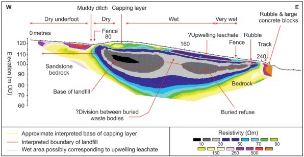
Geophysical methods have long been used to image landfills, their buried extents, structure, composition, and presence or otherwise of leachate. Different geophysical techniques highlight the physical and chemical characteristics of the material present.
By using enhanced multiple geophysical methods, it is possible to differentiate landfill cells and their contents and so focus landfill mining on the most appropriate locations within a site. Seismic techniques provide information about the physical properties while the electrical and electro-magnetic methods highlight the physico-chemical (fluid) content.
The information gained by non-invasive sensing of materials within a landfill could optimise possible resource recovery and land remediation to complement urban mining and recycling in general. This would help to recover more material (Waste-to-Material) and generate more energy (Waste to Energy) and reduce demand on the extraction of our rapidly depleting Earth’s virgin assets. We owe it to future generations to consume less of our planet’s resources and to use what we do extract more efficiently.
RIL has many years’ experience of landfill geophysics so contact us to find out how we can help with your landfill project.
Role of geophysics in former industrial (brownfield) sites
A brownfield site is “a former industrial or commercial site where future use is affected by possible environmental contamination”. These sites often contain hidden subsurface infrastructure and carry great uncertainty due to lack of information about their previous usage. This poses a challenge for redevelopment. Typically, the greatest risks are associated with the subsurface, where contaminants can persist from historic disposal practices, spills, and old infrastructure may remain unseen.
Recommended methods include: Electromagnetic (EM) surveys that measure changes in the conductivity caused by fluids, metals, and differing soil types; Magnetic-gradiometry, passive method that measures the contrasts in localised magnetic responses due to the presence of metallic and ferrous materials. The following types of surveys can discriminate anomalies, identifying targets such as tanks, pipes, cables, and foundations; Ground Penetrating Radar (GPR) uses pulsed electromagnetic waves to image ground structures often with very high resolution; Resistivity surveys capture how electrical current flows through soils and where it is inhibited or conducted. Resistivity surveys can be very sensitive to the presence of conductive fluids associated with contaminants, the water table, and geological structures.
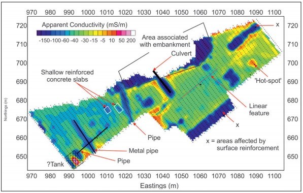
Reynolds International Ltd have designed and managed surveys for sites ranging from former factories to golf courses, landfills, quarries, inside shops and hospitals, airports, brownfield sites, etc., over many years. If you need advice on any aspect of a geophysical survey for any site but are unsure how to go about it, just ask us for an initial free consultation.
Surface wave techniques for engineering applications
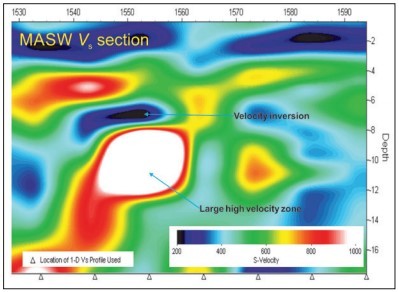
Interpreting geophysics into useful engineering properties can be tricky to say the least. What does a P-wave velocity of 2,000 m/s actually represent? What about a resistivity of 50 Ωm? Will the site support my foundations? Such information needs translating into a physical meaning that can be used by engineers.
Enter the surface wave survey. Measured shear wave velocity (Vs) is diagnostic of material type and, with additional density information, Vs can be converted into shear modulus (G), a diagnostic engineering parameter that indicates something specific to engineers.
Multi-channel Analysis of Surface Waves (MASW) is very popular for its ease of acquisition and production of 2D Vs sections quickly, typically to depths of 10-20 m (see image). Passive MASW is also becoming popular and works by measuring the Earth’s low frequency background noise over minutes or even hours and can resolve Vs to depths of over 100 m on a quiet site. MASW surveys are commonly undertaken using the same field layout as for P- and S-wave seismic refraction, which provide complementary information for only a small additional cost.
A second, related, technique, Continuous Surface Wave (CSW) analysis, uses a small vibrator source to propagate seismic energy at a range of frequencies into the ground. Typically, 1D plots of shear modulus (G) vs depth can be generated for multiple locations along a profile, usually to depths of 10-30 m. Once a field crew gets going, individual 1D profiles take only minutes to acquire.
Due to low acquisition cost, time effectiveness, and user-friendly software, non-expert users of surface wave methods are becoming increasingly common. However, surface wave methods present a complex problem as the solution is non-unique (i.e., several Vs models can reproduce the observed data). Poor quality results represent wasted time and money; data processing should be carried out by an experienced trained operative who can select the most appropriate method and parameters to obtain a geologically realistic result.
RIL has many years’ commercial experience of a variety of surface wave methods and can advise on any aspect of these methods. For a free initial consultation please contact us.
Drones: innovative deployment for geophysical sensors?
Airborne acquisition of geophysical data is not a new concept. Large-scale airbornegeophysical surveys via airplane or helicopter have been commonplace since the 1960s.
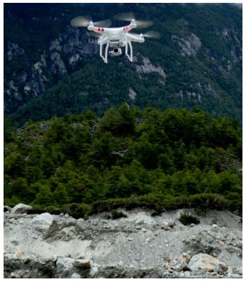
Drones have the potential to fill the gap between low resolution but expensive aircraft surveys and high resolution but labour-intensive ground-based surveys. Geophysical surveys often cover 10s of line kilometres, taking days to complete. Using a drone flying at ~20 km/hr, could reduce the time to just a few hours. Such automated efficiency has already enabled recent breakthroughs in LiDAR and photogrammetry surveying (see picture).
Unfortunately, it is not as simple as mounting existing sensors onto a drone and flying off into the sunset. Geophysical sensors are designed to be operated near to the ground surface. Despite new developments in terrain following, flying a sensor below a drone within ~1 m of the ground is not currently practicable or safe. Payload limitations currently preclude the use of heavier sensors without severely restricting flight time. Instrument noise from drone rotors means that sensors should be suspended well below the drone itself; however, this can reduce data quality as the sensor may not fly upright. UK drone laws are also a limiting factor, especially in built-up areas, with drone-based GPR suffering from a ‘doublejeopardy’ of two tightly regulated technologies.
Despite these constraints, serviceable droneacquired geophysical surveys are already possible. There has been a recent explosion of commercial magnetometry surveys via drone, with associated sensors and software quickly being developed. Other methods may follow closely behind, with drone-based EM and GPR sensors already commercially available. Additionally, potential for new applications of existing methods (e.g., the use of drone-deployed GPR for bathymetry) is already being realised.
Drone technology is developing at a terrific speed and may soon address many of the existing problems for geophysical surveys over difficult or difficult access terrain. As technology improves, expert opinion should be sought about sensor capabilities and modes of deployment; if it sounds too good to be true, it probably is! Nevertheless, drones will increasingly play a key part in optimising geophysical data collection. Please contact us for a free consultation to discuss your options.
Optimising intrusive investigations with geophysical methods
Geophysical surveying can quickly define the optimal locations of later intrusive testing, often reducing the amount for extensive intrusive works. The rapid data collection often results in a significant cost saving.
Another key benefit of a combined survey is that early geophysical results are used to make informed decisions on the intrusive locations, and are also used to constrain the geophysical outputs, producing a fully integrated ground model.
RIL have recently completed a large infrastructure project that tested numerous geophysical and intrusive techniques. This included the integration of seismic reflection, refraction, MASW, ERT, VETEM, and EM, with borehole, VSP, wireline and CPT datasets.
Five top tips for using geophysical techniques effectively
From over 40 years’ personal experience of engineering geophysics internationally, these five top tips will help to ensure a successful outcome to any environmental and engineering geophysics investigation:
- Ensure each geophysical survey is professionally designed with an appropriate technical specification using complementary methods where possible.
- Commission a competent geophysical contractor to acquire in accordance with the specification and have their work supervised as appropriate by a suitably qualified Engineering Geophysicist.
- Have the data analysed to maximise their value to aid appropriate interpretation.
- Constrain the geophysical interpretations where possible with appropriate intrusive techniques to provide the ground truth.
- Provide a suitably detailed report that addresses a client’s requirements clearly and concisely
Watch out for more details on each of these topics in our subsequent newsletters.
Weekly Volcanic Activity Report
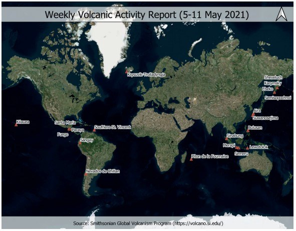
The Smithsonian Volcanic Program (SVP) publish a weekly report with the active volcanic activity around the globe. There are currently 47 volcanoes with ongoing eruptive activity of some sort (i.e., lava flows, explosions, pyroclastic flows, lahars, lava domes, and gas emissions). The map illustrates only volcanoes (red triangles) where a significant change in their behaviour has been reported to the SVP, including a rise of the alert level, or a volcanic ash advisory being released, during last week. There are three new activity reports compared with the previous week (Piton de la Fournaise, Nevados de Chillan, and Bulusan). Other volcanoes with ongoing eruptions include the well-known Mt. Etna, Stromboli, Erebus, Popocatepetl, and Yasur, among others.