August 2021 Newsletter

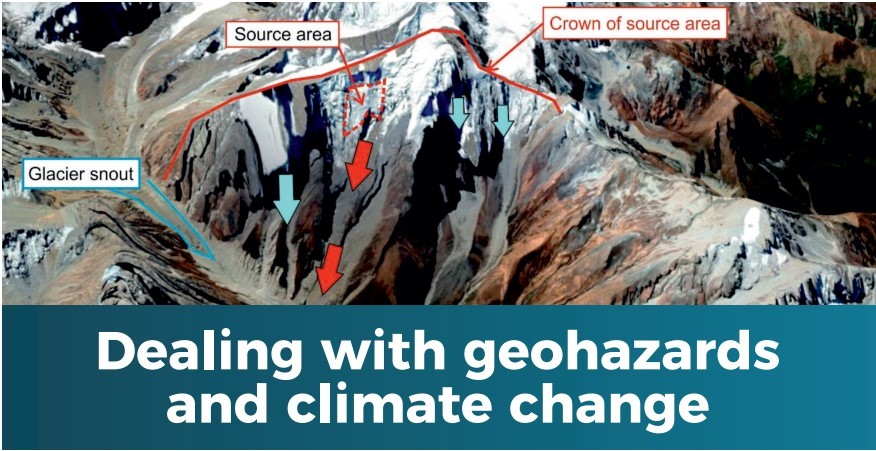
Welcome to this month’s newsletter with the focus on Geohazards. The hydropower sector should take note of two important events. The first was the lethal rock and ice landslide in the Chamoli District of Uttarakhand, India, that left ~200 people dead or missing, and destroyed and badly damaged two large hydropower schemes under construction. The tragedy was not that the large landslide occurred but that two hydropower schemes had been approved for construction downstream of what was a highly unstable mountain. Our analysis of this is being published in The International Journal of Hydropower & Dams in its September 2021 issue.
The second pivotal event was the release of the IPCC Working Group 1’s report on ‘The physical basis of climate change’. In short, it is a real and stark wake-up call to society in general that real and drastic action must be taken urgently if rises in average global temperatures are to be held anywhere near the agreed 1.5°C target. Even in the unlikely case that this target is met, sea level will continue to rise for many years to come. Society needs to ramp up its response to this enormous challenge. Some aspects of climate change as discussed on pages 2 and 4.
As a company, RIL continues to play its part both in working to decarbonise electricity generation through our offshore renewable energy projects (offshore wind, and tidal stream and tidal range projects) as well as through hydropower development in high mountains.
Read on to find more about these topics and benefit from our top tips to build resilience to geohazards in hydropower development.
Modelling the impact of landslides into glacial lakes

Recent advances in technology have enabled the development of numerical simulation routines to model physical processes that aid our understanding of such processes. At present, there are many commercial and opensource options that address this subject using different approaches and set of equations. Many have been developed ad hoc for studying a particular process and have gradually incorporated a wider range of capabilities (i.e., RAMMS for avalanches; MIKE for floods). One key aspect when modelling geohazards is the effect of cascading processes, such as an avalanche impacting a lake, which then overtops the dam flooding the downstream valley. R.avaflow is an open-source code that enables the modeller to simulate these cascading events from a multiphase — solid, fine solid, and fluid — perspective. The graphic shows an example of a simulated generic avalanchelake interaction. It illustrates a snapshot at 250 s after the onset of the avalanche and how the lake water body responded. Avalanche original source (circle) and its deposits are depicted in red, while lake water volume is illustrated in blue (darker blue colours refer to deeper water column). The figure shows already the downstream effects of the dam overtopping caused by the avalanche-lake interaction.
Software like r.avaflow enable the user not only to model these processes but also to quantify questions such as: how high would the overtopping wave be? What would be the peak discharges downstream at several distances from the lake’s dam? How much erosion would the dam suffer, and would it collapse? These and many other queries can be addressed with the careful and informed use of modelling software, bearing in mind the inherent caveats and uncertainties of the modelling parameters. Although back-analysis of past events has been proven successful with the use of such software, their use in forecasting is still limited. In fact, having a clear and concise idea as to the sensitivities of the equations and parameters is key to a successful and realist model.
RIL has many years’ experience of glacial hazard assessment experience in high mountain environments so contact us to find out how we can help with your hydropower project.
Climate change - latest hot news…
Headlines from the IPCC Working Group 1’s report include:
- Human-induced climate change is already affecting our weather with climate extremes across the globe – heatwaves, drought, wildfires, intense precipitation, flooding, more frequent and more powerful cyclones/hurricanes, shrinking glaciers and ice sheets.
- Global warming of 1.5°C and 2°C are likely to be exceeded unless drastic action is taken urgently.
- Many changes due to past and future greenhouse gas emissions are irreversible for centuries to millennia, including sea level rise.
- The long-term viability of island states and some low-lying coastal fringes is becoming increasingly fragile.
- And the list goes on…
Despite these stark statements, the IPCC Report’s authors do give a glimmer of hope. Society can just about do enough to limit warming to 1.5°C if greenhouse gas emissions are cut drastically. In the period 2000 to 2019, China’s gas emissions sored from 3.34 billion tonnes of CO₂ to 10.17 billion, almost equalling the sum of emissions from all the next four largest emitters combined - USA (5.28 bn), India (2.61 bn), Russia (1.67 bn) and Japan (1.1 bn) (data from Global Carbon Project). China is only slated to reach ‘carbon neutrality’ in 2060, which is far too late. In the meantime, the most vulnerable and poorest countries like Nepal are already struggling with the negative impacts of climate change.
It is high time society and governments around the world wake up to the growing reality of the severe impacts of our changing climate and take action now before it is too late. We owe it to our children and grandchildren and to the generations to come to play our part now.
Forthcoming Report on the Glacial Hazard Assessment of the Pumqu Basin, Tibet
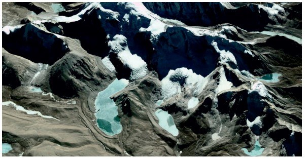
The Pumqu Basin in southern Tibet has an area of ~25,500 km² and, along its border with northern Nepal, is heavily glacierised with many glacial lakes. The area has been the source of several historical catastrophic Glacial Lake Outburst Floods (GLOFs), the largest of which have travelled into and caused substantial damage in northern Nepal. Nepal is endeavouring to increase its installed capacity for hydropower electricity generation not only to supplement the existing but insufficient provision (~1 GW) for domestic consumption but to provide enough excess power for export to earn much needed revenue. Within the upstream Arun River catchments, a cascade of five hydropower schemes is in development, totalling an installed capacity of ~3.2 GW with an asset cost of ~$5.6 billion. The area is also seismically active and highly prone to landslide activity. The Himalayas represent an extremely dynamic physical environment.
Given the value of the hydropower assets in the Arun Valley, as well as the presence of riparian communities and other infrastructure along the river, the existence of glacial lakes upstream is of concern with respect to possible GLOFs. The question is which of the glacial lakes pose a hazard and to what degree. RIL staff have been at the forefront of glacial hazard assessment research for more than three decades and are acknowledged independently to be the world leaders in this field. We have almost 30 years’ experience of working in Nepal so are well placed to be able to apply the latest techniques to assess glacial hazards.
We are pleased to announce that our assessment of glacial hazards within the Pumqu Basin will be available within the next couple of months – watch our website for announcements. It will be a very comprehensive analysis and include numerical simulation of possible landslides into selected glacial lakes to determine the possibility of moraine dam breaches and the development of GLOFs. Furthermore, it is now possible to use the information derived from numerical simulations as input to flood modelling software to estimate flood run-out distances, peak discharges, and produce possible inundation maps.
Please contact us if you are interested in purchasing a copy of the Report.
Rest and Be Thankful or look out and be careful!
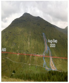
The A83 is a key road connecting Argyll and Bute with Central Scotland with several thousand vehicles crossing every day and provides the main access from north of Glasgow to a large part of western Scotland with alternative routes involving a long detour. The stretch of road known as Rest and Be Thankful is notorious, being frequently closed due to the fall of material (in the form of rockfalls and debris flows) from the uphill slope. This mostly consists of schists overlayed with 2-4 m of glacial till, with many interspersed gullies that funnel run-off during prolonged rainfall ringing fine and coarse sediment downhill. During the 17-year period 2003 to 2020 alone, nearly 60 events were recorded, including creep deformation, debris falls, and debris flows. The picture shows a panoramic view of the slope, depicting the A83 road (red dashed line) and outlining (blue line) the most recent event recorded in August-September 2020. The brief period 2017-2018 was particularly ‘productive’ in terms of slope movements with 19 events. These slope instability processes have caused many road closures over the years (costing on the order of ~£90k per day), and over £13 M have been spent on mitigation measures such as catch-nets, catch-pits, and culverts.
Recent studies highlight the correlation of these slope failures with precipitation rates and ground saturation. Most events occur during the winter months, when precipitation rates are at their highest, with some notable exceptions as the events recorded during August-September 2020 that shut the A83 for more than a hundred days. Newcastle and Northumbria universities are working closely with local authorities (BEAR Scotland, Transport Scotland) to monitor the site using a multidisciplinary network that includes weather stations, differential GPSs, visual imagery and feature vector tracking, seismic sensors, and frequent LiDAR scans, all connected through a local Wi-Fi network.
Data are streamed in real time to both universities and stakeholders, where they are analysed through a cloud portal. A combination of empirically derived thresholds put all data together and alerts are issues whenever these threshold values are exceeded. This showcases a multidisciplinary near real-time geohazards monitoring scheme, key for other unstable slopes around the globe.
Challenges and innovation at the HYDRO 2021 conference, Strasbourg
The international hydropower conference, HYDRO 2021,
organised by Aqua-Media, is due to be held in Strasbourg, France, 25th-27th October 2021. RIL’s Prof. John M. Reynolds will be giving an oral presentation on ‘Integrated Geohazard Assessments to increase resilience of hydropower schemes to natural disasters incorporating lessons learned from the February 2021 Chamoli disaster, N. India”. This is a combined presentation that incorporates a summary of the disaster in India with key lessons learned with a discussion as to the merits of undertaking Integrated Geohazard Assessments of upstream catchments for any hydropower scheme, especially in a high mountain environment. His full paper with colleague Dr Alejandro Diaz-Moreno about the Chamoli disaster is scheduled to be published in The International Journal of Hydropower & Dams in the September 2021 issue.
Five top tips to build resilience to geohazards in hydropower schemes
From over 45 years’ personal experience of glacial hazards internationally, these five top tips will help a hydropower developer increase their project’s resilience to geohazards and reduce the risk of damage from natural disasters:
- Undertake sufficiently detailed site risk assessments.
- Review all separate risk reports collectively to understand how each can influence the other, i.e., earthquakes triggering slope instabilities, climate change producing more frequent, larger magnitude, weather extremes, etc.
- Commission RIL to undertake a comprehensive Integrated Geohazard Assessment of the upstream watershed.
- Develop a dynamic Risk Register and a comprehensive Disaster Risk Reduction Action Plan and communicate these to all key stakeholders.
- Update all the above on a regular basis, in some cases, annually, or at the very least once every five years, depending upon how active the watershed physical processes are
Watch out for more details on each of these topics in our subsequent newsletters.
Geo-Factoid - Greenland extreme melting event summer 2021
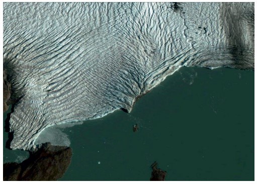
The Danish Meteorological Institute has reported this month that a record-breaking heatwave in Greenland has resulted in temperatures >10°C above seasonal norms that have caused a “massive melting event” of the island’s ice sheet. Around 8 billion tons of ice melted per day, twice its normal average rate during the summer. This single event produced enough meltwater to cover an area equivalent to that of England and Wales with almost 6 cm of water. While the largest seasonal melting occurred in 2019, the area affected this year was larger than that in 2019. Recent mass loss is now around four time greater than it was before 2000, contributing to increasing rates of sea level rise.